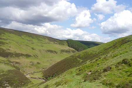
Fairbrook Naze & Ashop Head from Birchen Clough
Peak District Walk
Nat Park - Peak District - Kinder Scout Edale
County/Area - Derbyshire
Author - Andy Chaplin
Length - 9.3 miles / 15.1 km Ascent - 1500 feet / 455 metres
Time - 6 hours 10 minutes Grade - moderate
Maps 

| Ordnance Survey Explorer OL1 | Sheet Map | 1:25k | BUY |
| Anquet OS Explorer OL1 | Digital Map | 1:25k | BUY |
| Ordnance Survey Landranger 110 | Sheet Map | 1:50k | BUY |
| Anquet OS Landranger 110 | Digital Map | 1:50k | BUY |
Walk Route Description
Click image to see photo description.
This Peak District walk takes an interesting route up Fair Brook to reach the Kinder Scout Plateau before following the northern edge to Ashop Head. The return route is via the Snake Path with good views across the valley to the edges walked on the outward route. The walk avoids many of the problems of peat hags and can be walked for most of the year. However, in low cloud a good sense of direction is required especially at Ashop Head.
The Snake Road is always to be avoided for walking whenever possible and the following route avoids walking along this busy road. Go over the stile on the north-east side of the Birchen Clough car park and take the path signposted to Alport Bridge. Follow this path through the Snake Woods until you reach a sign indicating a track down to the Snake Inn. Reaching the Snake Road cross straight over and follow the path left and then down towards the river. From the bank above the river there is a reasonably well-defined path that follows the fence line off to the left above the river (not down on the river bank) which eventually comes out at a bridge (grid ref SK114902).
Cross the bridge and follow the river downstream before turning right at the first brook. This is Fair Brook. Follow this upstream staying on the west side for the climb onto the Kinder Scout Plateau. Near the top your scramble up through rocks to reach the edge path. Turn right to reach Fairbrook Naze, which looks like a ship's prow from the valley.
Stay on the edge path with good views to your right. Away to your left are the peat hags that make Kinder so infamous! Generally, the path is fairly dry although there are some unavoidable sections that can be wet and boggy after rain. As you continue along the edge, heading almost due west, you will pass some interesting weathered millstone grit rock features including the "Boxing Gloves".
After about two miles (which in fact seems much longer) you reach the Pennine Way at the top of Ashop Head. Turn right and descend steeply over a flagged path to Ashop Head. At the cross path (Grid ref. SK063902) turn right. This is the Snake Path, which leads you back to the start. In places, it can again be boggy although most of the worst sections have now been paved. Entering the woods (grid ref. SK102907) keep on the lower path that runs parallel to the River Ashop. Cross the footbridge and turn left continuing back to the parking area at Birchen Clough.
Other walks nearby
| Walk 1489 | Blackden Brook, Kinder & Upper Ashop | moderate | 6.8 miles |
| Walk 3049 | Bleaklow Stones from Derwent Valley | mod/hard | 12.0 miles |
| Walk 1159 | Grindsbrook & Edale Head | moderate | 7.5 miles |
| Walk 1264 | Rushup Edge & Crowden Tower | moderate | 10.0 miles |
| Walk 1295 | Ringing Roger & Edale Cross | moderate | 10.0 miles |
| Walk 2595 | Castleton Great Ridge from Edale | moderate | 8.5 miles |
| Walk 2615 | The Kinder Edges | mod/hard | 18.0 miles |
| Walk 3350 | Kinder Scout Summit | moderate | 8.5 miles |
| Walk 1113 | Ringing Roger & Grindslow Knoll | moderate | 5.5 miles |
| Walk 1300 | Hope Cross & Ringing Roger | moderate | 8.0 miles |
Recommended Books & eBooks
Walking in Derbyshire
 Walking guidebook to 60 circular day walks in Derbyshire and the Peak District. Includes the Derwent, Wye and Trent river valleys, near Derby, Matlock, Glossop, Bakewell and Ripley. Routes range from easy to moderate and are between 4 and 14km (2 to 10 miles). Walks focus on places of interest, from Stone Age forts to castles to grand estates.
More information
Walking in the Peak District - White Peak East
 Guidebook describing 42 half-day and day walks in the limestone landscapes of Derbyshire's White Peak, part of the Peak District National Park. One of two volumes, this book covers the east of the region, with potential bases including Bakewell, Eyam, Castleton, Birchover, Matlock and Wirksworth.
More information
Messaging & Social Media
Message Walking Britain and follow the latest news.

Mountain Weather
Stay safe on the mountains with detailed weather forecasts - for iOS devices or for Android devices.