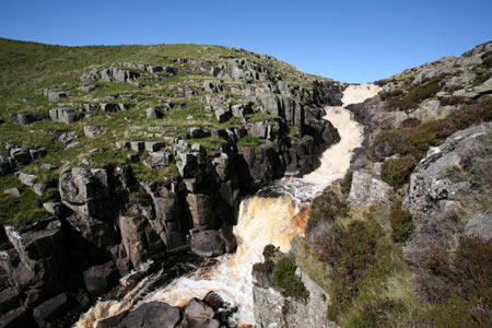
Cauldron Snout from Cow Green Reservoir
North Pennines Walk
Region - North Pennines
County/Area - Durham
Author - Lou Johnson
Length - 3.6 miles / 5.9 km Ascent - 300 feet / 91 metres
Time - 2 hours 10 minutes Grade - easy
Maps 

| Ordnance Survey Explorer OL19 | Sheet Map | 1:25k | BUY |
| Anquet OS Explorer OL19 | Digital Map | 1:25k | BUY |
| Ordnance Survey Landranger 91 | Sheet Map | 1:50k | BUY |
| Anquet OS Landranger 91 | Digital Map | 1:50k | BUY |
Walk Route Description
Click image to see photo description.
This is an easy walk ideal for filling in a few hours if you are in the North Pennines. The area around Cow Green Reservoir is typical of this part of England with wild moors and hills that see few visitors apart from sheep. Cow Green Reservoir was built amid some controversy between 1967 and 1971 so is one of the more recent additions to water storage in the UK. The key feature visited is Cauldron Snout waterfall on the River Tees, which after a long wet spell can be very spectacular. If you have time you can extend the walk to visit the impressive limestone crags that form Falcon Flints a little further downstream.
The start is the small car park above Cow Green Reservoir (grid ref. NY810309) where you immediately get a feeling of the wild country forming this part of the North Pennines. From the car park walk back up the road and take the first path on the right (grid ref. NY812307) heading roughly south east. Reaching a cross track, turn left and continue to a tarmac track. Turn right and follow this access road to the dam to join the Pennine Way. Do not cross the bridge but bear left onto the Pennine Way heading south to Middleton-in-Teesdale. The waterfall is a short distance downstream below the bridge. If you wish to visit Falcon Flints, then continue along the Pennine Way as far you wish. The return route follows the outward path.
Other walks nearby
| Walk 3424 | Cronkley Fell from Hanging Shaw | easy/mod | 7.0 miles |
| Walk 3526 | Hanging Shaw, Cronkley Scar, Low Force & High Force | moderate | 12.7 miles |
| Walk 1659 | Race Head & Sedling Rake from Wearhead | easy/mod | 6.0 miles |
| Walk 3099 | High Force, Low Force and the River Tees | easy/mod | 7.5 miles |
| Walk 3758 | Tynehead and Ashgill Force from near Garrigill | easy/mod | 8.2 miles |
| Walk 2393 | Weardale Circular from Westgate | easy/mod | 6.4 miles |
| Walk 1084 | Garrigill, Alston & Nenthead | moderate | 13.1 miles |
| Walk 1339 | High Cup Nick | moderate | 10.5 miles |
| Walk 3011 | Dufton Pike | easy/mod | 5.5 miles |
| Walk 3070 | Knock Fell & High Cup Nick | mod/hard | 12.0 miles |
Recommended Books & eBooks
Walking in the North Pennines
 This guidebook describes 50 day walks across the North Pennines, England's remotest Area of Outstanding Natural Beauty taking in parts of Cumbria, County Durham and Northumberland. Most of the routes are circular and they range from 5 to 14 miles, with something to suit all abilities. Route descriptions are accompanied by 1:50K OS mapping.
More information
Great Mountain Days in the Pennines
 An inspirational guidebook to 50 classic walks on the rolling Pennine landscape. The graded routes, between 6 and 13 miles in length, cover classic Pennine fells and moorland such as Whernside, Ilkley Moor and Pendle Hill; exploring the North and South Pennines, Yorkshire Dales, Howgills and Dark Peak. Many routes are also suited to fell running.
More information
Messaging & Social Media
Message Walking Britain and follow the latest news.

Mountain Weather
Stay safe on the mountains with detailed weather forecasts - for iOS devices or for Android devices.