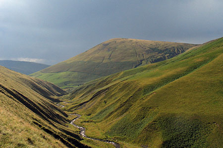
Carlingill Beck, Black Force & Whin's End
Howgills Walk
Region - Howgills
County/Area - Cumbria - Howgill Fells
Author - Lou Johnson
Length - 6.5 miles / 10.6 km Ascent - 1200 feet / 364 metres
Time - 4 hours 30 minutes Grade - mod/hard
Maps 

| Ordnance Survey Explorer OL19 | Sheet Map | 1:25k | BUY |
| Anquet OS Explorer OL19 | Digital Map | 1:25k | BUY |
Walk Route Description
Click image to see photo description.
This walk in the Howgill Fells starts from Carlingill Bridge and initially follows Carlingill Beck upstream to reach Black Force waterfall which tumbles down in a series of cascades. From here the route follows paths and tracks over Whin's End to descend to follow Howgill Lane and then Fairmile Road back to the start. For the most part it is a relaxing walk. However, the ascent beside Black Force is a rough scramble. After heavy rain, this route can, in places, be impassable or difficult to make progress.
The start is a grassy lay-by on the south side of Carlingill Bridge (grid ref. SD624995). After parking walk back to the bridge and turn right dropping down to pick up the path on the south side of Carlingill Beck (beck on your left). As you make progress upstream you will need to cross the beck to find the easiest route. If the stream is running deep, then you can make progress by heading steeply up to your right to join a feint path that descends across the fell to re-join the beck near Green Knott Gill. After two kilometres from the start you arrive at the foot of the Black Force ravine on your right. It is worth noting that the final 200 metres before Black Force you may have to wade along the stream bed.
The scramble starts at the foot of the ravine. The preferred route is to the left of the cascades. It is steep in places and needs care. As you make progress up the steep slope you reach a grassy arete. After this the slope starts to ease and you should cross Little Ulgill Beck where convenient towards a narrow path that leads up to an obvious track (grid ref. SD645990).
Turn south and follow the track across the western flank of Blake Ridge to reach a col (grid ref. SD640985). Continue south with the slopes of Fell Head rising to your right. As you make progress you can fully appreciate the rounded contours of the Howgill Fells. After crossing Blind Gill, the path descends gently to Whin's End. From here initially head left before heading south to cross two small becks. Just beyond the second beck follow a narrow path that descends parallel to the beck to reach Beck Houses Gate (grid ref. SD638969). Joining a tarmac track, you soon pass Gate House before reaching Howgill Lane.
Turn right along Howgill lane which passes between fields for about 1.5 kilometres to reach open country. The lane becomes Fairmile Road and leads easily back to the start. The road walking is pleasant, and you have a fine view along the Lune Valley on your right.
Other walks nearby
| Walk 3007 | Fell Head & The Calf from Howgill | moderate | 7.5 miles |
| Walk 2458 | Winder, The Calf & Fell Head | moderate | 9.8 miles |
| Walk 1839 | Blease Fell & Hare Shaw from Tebay | easy/mod | 5.7 miles |
| Walk 1616 | Bowderdale and the Calf | moderate | 10.0 miles |
| Walk 3006 | Cautley Spout & The Calf | moderate | 5.5 miles |
| Walk 1393 | Yarlside | moderate | 4.0 miles |
| Walk 1387 | Cautley Spout | easy | 2.0 miles |
| Walk 1342 | Randygill Top from Weasdale | moderate | 6.0 miles |
| Walk 3008 | Winder & Arant Haw from Sedbergh | moderate | 7.0 miles |
| Walk 2438 | Cautley Spout & the Calf from Sedbergh | moderate | 10.0 miles |
Recommended Books & eBooks
The Cumbria Way
 A guidebook to the 73 mile Cumbria Way, an easy long-distance walk though the heart of the Lake District National Park, from Ulverston in the south to Carlisle in the north, with good transport links to either end. The route is largely low-level but this guide offers alternative mountain days to climb some of the famous fells en route.
More information
Walking the Lake District Fells - Wasdale
 Part of the Walking the Lake District Fells series, this guidebook covers a wide range of routes to 25 Lakeland summits that can be climbed from the Wasdale, Eskdale and Ennerdale valleys, with highlights including Scafell Pike, Great Gable and Pillar. Suggestions for longer ridge routes are also included.
More information
Messaging & Social Media
Message Walking Britain and follow the latest news.

Mountain Weather
Stay safe on the mountains with detailed weather forecasts - for iOS devices or for Android devices.