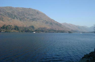
Place Fell from Patterdale
Lake District Walk
Nat Park - Lake District - Lake District Far Eastern Fells
Wainwrights - Place Fell
County/Area - Cumbria
Author - John Paterson
Length - 7.5 miles / 12.2 km Ascent - 1700 feet / 515 metres
Time - 5 hours 30 minutes Grade - moderate
Maps 

| Ordnance Survey Explorer OL5 | Sheet Map | 1:25k | BUY |
| Anquet OS Explorer OL5 | Digital Map | 1:25k | BUY |
| Ordnance Survey Landranger 90 | Sheet Map | 1:50k | BUY |
| Anquet OS Landranger 90 | Digital Map | 1:50k | BUY |
Walk Route Description
Click image to visit gallery of 9 images.
Place Fell occupies a wonderful position on the shore of Ullswater and the views, especially over the lake to the Helvellyn range, are excellent. Although of moderate difficulty, this Lake District circular walk is reasonably long and the return path along the lake shore footpath from Sandwick, whilst beautiful, is not the gentle stroll which might be imagined from a glance at the map!
Start: There is free parking in a lay-by (GR NY397158) for a few cars on the east side of the road 75 yards south of Patterdale Post Office. If this is full, then a pay and display carpark (GR NY395159) can be found opposite the Patterdale Hotel 120 yards north of the lay-by.
Head south along the road from the post office and after 150 yards turn left down a minor road which leads across Goldrill Beck to the hamlet of Rooking. At Rooking, follow the lane to the left up the hill for 50 yards until a signpost to the right points to the path to Boredale Hause. This is a good path which rises steadily in a south easterly traverse towards the hause. The views back down to the valley are excellent and ahead the view opens up towards Brothers Water and the Kirkstone Pass. The hause is a wide pass, almost a plateau, (GR406157) but before the true summit of the pass is reached, a choice of several paths heads off left towards the summit of the fell. Choose whichever path you wish - as long as it heads north it will take you quite steeply to the false summit of Round How before a more gentle path past some small tarns leads to the true summit a few hundred yards further on.
Place Fell summit is well worth a long stop for lunch and to take in the views. To the north east the Pennines can be seen on a clear day. South east is the long ridge of High Street and to the west the views of the Helvellyn range (seen over Ullswater and Glenridding) are unsurpassed. Head north from the summit to pass a rock formation known as the Knight and follow the path as it curves east to reach a sheepfold at the depression of Low Moss (GR414178). There is a choice of ways here. The most interesting way is to take a middle way between the two paths marked on the map and head north over the minor top of High Dodd and the shoulder of Sleet Fell and down into the hamlet of Sandwick. When the unfenced road is reached, turn left and follow the road for a few yards until you are just short of the farm when you should turn left onto the lake shore path running above the fell wall.
The lake shore path stays about a hundred feet above the lake. The scenery surrounding the path is delightful and the underfoot conditions are good. However, it is very undulating with a few steep climbs and descents and the 3.5 miles back to Rooking may seem longer to tired legs. Once back at Rooking, recross Goldrill Beck and turn right at the main road to reach the start of the walk.
Other walks nearby
| Walk 1156 | Helvellyn via Striding Edge | hard | 9.5 miles |
| Walk 1235 | Red Tarn & Grisedale | moderate | 7.0 miles |
| Walk 1710 | Glenridding, St. Sunday Crag & Helvellyn | hard | 11.5 miles |
| Walk 3232 | Glenridding Dodd & Sheffield Pike | easy/mod | 4.5 miles |
| Walk 2327 | Red Tarn & Birkhouse Moor from Glenridding | moderate | 6.0 miles |
| Walk 3668 | Catstye Cam from Glenridding | mod/hard | 7.0 miles |
| Walk 1110 | Angletarn Pikes | moderate | 7.0 miles |
| Walk 2060 | The Angletarn Pikes and Brock Crags from Hartsop | moderate | 8.0 miles |
| Walk 3388 | Hayeswater and Angle Tarn from Hartsop | mod/hard | 11.5 miles |
| Walk 2386 | Red Screes via Dove Crag | mod/hard | 8.6 miles |
Recommended Books & eBooks
Walking the Lake District Fells - Patterdale
 Part of the Walking the Lake District Fells series, this guidebook covers a wide range of routes to 35 Lakeland summits that can be climbed from Ambleside, Grasmere and Patterdale and the Thirlmere and Ullswater valleys, with highlights including Helvellyn and Fairfield. Suggestions for longer ridge routes are also included.
More information
Walking the Lake District Fells - Buttermere
 Part of the Walking the Lake District Fells series, this guidebook covers a wide range of routes to 32 Lakeland summits that can be climbed from the Buttermere, Lorton and Newlands valleys, with highlights including Haystacks, High Stile, Grasmoor and the fells of the Coledale Round. Suggestions for longer ridge routes are also included.
More information
Messaging & Social Media
Message Walking Britain and follow the latest news.

Mountain Weather
Stay safe on the mountains with detailed weather forecasts - for iOS devices or for Android devices.