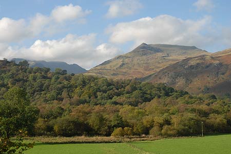
The Angletarn Pikes and Brock Crags from Hartsop
Lake District Walk
Nat Park - Lake District - Lake District Far Eastern Fells
Wainwrights - Angletarn Pikes, Brock Crags
County/Area - Cumbria
Author - Lou Johnson
Length - 8.0 miles / 13 km Ascent - 2050 feet / 621 metres
Time - 6 hours 0 minutes Grade - moderate
Maps 

| Ordnance Survey Explorer OL5 | Sheet Map | 1:25k | BUY |
| Anquet OS Explorer OL5 | Digital Map | 1:25k | BUY |
| Ordnance Survey Landranger 90 | Sheet Map | 1:50k | BUY |
| Anquet OS Landranger 90 | Digital Map | 1:50k | BUY |
Walk Route Description
Click image to visit gallery of 12 images.
This Lake District circular walk offers a number of excellent panoramas across the surrounding Lakeland fells. The walk does contain some uphill work but the effort is well rewarded. This route also contains one section of rough fell walking without any paths and care should be taken on this section. The start is the small car park at Cow Bridge (Grid ref. NY403134) on the A592 between Patterdale and Kirkstone Pass. This can be very busy on fine days and an early arrival is recommended. After parking follow the main road towards Hartsop village turning left off the main road into a lane. Continue down this lane for a short way and turn left again onto a farm access road. Where the tarmac lane bears right, continue ahead to Dubhow where a path rises across the fellside to Boredale Hause.
Nearing the hause the path steepens so it is a good place to take a break and enjoy the view. Across the valley lie Helvellyn, St Sunday Crag and many other high fells. Despite the relatively low altitude at the hause, the panorama is extensive especially if you take a few minutes to seek out the views. Turning south to cross a stream, the well used path towards the Angletarn Pikes is soon located. This starts a gentle ascent passing through a narrow valley to reach the open fell. At the first junction bear left and continue to climb towards the Pikes. Just after the path junction look out for a feint path on the left which provides access to both of the summits of the Angletarn Pikes. The climb is easy and the reward is a grand panorama which now includes the High Street range and many other Lake District Fells.
Rather than return to the main path, leave the second (most easterly) summit and continue roughly due east over rough fellside to join the path coming from Bedafell Knott. This path is clear on the ground and providing you maintain a consistent bearing off the summit of the second Angletarn Pike summit then the path will soon be reached. Turn right down this path with a good view to the left into Bannerdale with Angle Tarn below on your right. Stay on this path as it descends to meet the main path on the eastern shore of the Tarn. This is another spot where a rest may be appropriate as the setting is very beautiful and the mountain backdrop spectacular.
Continuing along the main path you soon reach a wall (Grid ref NY421138). Turn right here and follow the path ESE to Brock Crags. There is one section of wet ground on the way but this can easily be overcome to reach the cairn, which offers a spectacular view down to Hartsop village and to the surrounding fells. Return back to the main path and continue past Satura Crag keeping the wall on your right. Near Satura Crag there are excellent views into Bannerdale and across the Deer Forest to The Nab and this is worth the short diversion to your left.
Be careful not to take the path heading half left up to the summit of the Rest Dodd, instead staying beside the wall on a clear path At times the path is soft although do not let this deter you as you continue towards the Knott. Reaching a cross wall (grid ref. NY433131), turn south west down the hillside to the small footbridge across the outlet from Hayeswater. This reservoir is dramatically located in a deep u-shaped valley with High Street providing a backdrop. Cross the footbridge and follow Hayeswater Gill downstream. The gill is particularly pretty as it cascades down the valley towards Hartsop. The track passes the slopes of Gray Crag and descends to a bridge (Grid ref. NY416128). Cross this and continue down the track towards Hartsop. Continue through the village to reach the main road from where it is a short walk back to Cow Green car park.
Other walks nearby
| Walk 3309 | Hartsop, Hartsop Dodd, Stony Cove Pike & Kirkstone Pass | moderate | 8.5 miles |
| Walk 1228 | Thornthwaite Beacon & High Street | moderate | 6.5 miles |
| Walk 1959 | Gray Crag and Pasture Beck from Hartsop | moderate | 5.5 miles |
| Walk 2585 | Hartsop Dodd, Stony Cove Pike, High St. & The Knott | mod/hard | 10.0 miles |
| Walk 1230 | Birks & Arnison Crag | moderate | 5.5 miles |
| Walk 1520 | Helvellyn & Fairfield Horseshoe from Patterdale | very hard | 13.0 miles |
| Walk 2047 | Place Fell | moderate | 7.5 miles |
| Walk 2425 | Boredale Circular from Patterdale | mod/hard | 11.5 miles |
| Walk 3670 | Angle Tarn and Hayeswater | moderate | 8.3 miles |
| Walk 1156 | Helvellyn via Striding Edge | hard | 9.5 miles |
Recommended Books & eBooks
Lake District: High Level and Fell Walks
 This guidebook describes 30 graded fell walks on the ridges and high peaks of the English Lake District, the UK's most popular national park. Reaching some of England's finest and highest mountain scenery, this guide leads readers to classic horseshoes and traditional ascents as well as lesser-known routes to quieter summits.
More information
Great Mountain Days in the Lake District
 An inspirational guidebook to 50 challenging walks on the high fells of the Lake District. The graded circular routes, between 4 and 14 miles in length, cover classic Lakeland summits like Fairfield, Scafell Pike, Great Gable and Blencathra, to the lesser-known High Spy, King's How and Brund Fell.
More information
Messaging & Social Media
Message Walking Britain and follow the latest news.

Mountain Weather
Stay safe on the mountains with detailed weather forecasts - for iOS devices or for Android devices.