Great Wishford & Grovely Lodge
Wiltshire Walk
County/Area - Wiltshire
Author - Lou Johnson
Length - 6.6 miles / 10.7 km Ascent - 700 feet / 212 metres
Time - 4 hours 0 minutes Grade - easy/mod
Maps 

| Ordnance Survey Explorer 130 | Sheet Map | 1:25k | BUY |
| Anquet OS Explorer 130 | Digital Map | 1:25k | BUY |
Walk Route Description
Click image to see photo description.
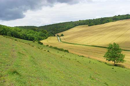
This Wiltshire walk from near Great Wishford combines areas of mature woodland with open downs. The undulating route follows good paths and bridleways and includes a section of the Monarch's Way. Refreshments are available in the attractive village of Great Wishford towards the end of the walk.
The start is the small free car park at the top of Groveley Road about two kilometres southwest of Great Wishford (grid ref. SU062347). (Limited on street parking is also available in Great Wishford.) After parking continue ahead on the clear track into woodland. You are now following a section of the Monarch's Way. Continue ahead through Groveley Wood following trail to reach a cross track on the edge of open fields. Cross straight over and continue past Groveley Grange on your right.
Follow the Monarch's Way into woodland and keep right at the first junction after entering trees. Continue ahead to reach Groveley Farm (grid ref. SU044335). Turn left, leaving the Monarch's Way, along the edge of the wood (on your left). Continue ahead soon passing through trees. After exiting the wood, maintain direction across a field to reach the Ox Drove (grid ref. SU047327). Turn left and continue along the clear track. The track soon becomes a narrow tarmac lane, which is followed until the lane bends right (grid ref. SU569324).
At this point turn left onto a grassy track to the left of a milestone. Follow the enclosed path for a kilometre top reach woodland. Continue ahead through Groveley Wood. Go straight across First Broad Drive (grid ref. SU065377) and continue through the wood to exit onto downland. Continue ahead following the track as it bends right to pass under the railway and reach a road (grid ref. SU080351).
Turn left and almost immediately fork right along South Street. Continue to the parish church. Just before the church bear left and continue to a T-junction. Turn left along West Street, rejoining the Monarch's Way. Reaching The Royal Oak, continue ahead with pub on your right, pass under the railway and continue up the lane back to start.
Other walks nearby
| Walk 2465 | Steeple Langford Circular | moderate | 9.8 miles |
| Walk 3727 | Normanton Down & Stonehenge from Great Durnford | easy/mod | 8.2 miles |
| Walk 3626 | The Fovant Badges from Broad Chalke | easy/mod | 9.3 miles |
| Walk 3237 | Bowerchalke & the Ox Drove | easy/mod | 8.0 miles |
| Walk 2171 | Knighton Hill & the Ox Drove | easy/mod | 5.8 miles |
| Walk 3679 | Wardour Castle, Ansty Down & Wardour Park | easy/mod | 7.5 miles |
| Walk 2343 | Higher Pertwood & Wessex Ridgeway from Hindon | easy/mod | 8.1 miles |
| Walk 3632 | Battlesbury Hill from Norton Bavant | easy/mod | 6.0 miles |
| Walk 2448 | Ackling Dyke from Sixpenny Handley | easy/mod | 8.6 miles |
| Walk 2255 | Urchfont Hill from Market Lavington | easy/mod | 8.6 miles |
Recommended Books & eBooks
The Kennet and Avon Canal
 Guidebook to walking along the Kennet & Avon Canal. The 94 mile route from Reading to Bristol is split into 7 stages of fairly easy walking and includes the UNESCO World Heritage Site of Bath and Bristol's Floating Harbour. 20 circular walks are also included, ranging from 4¼ to 9 miles, taking in the best sections of the canal.
More information
Messaging & Social Media
Message Walking Britain and follow the latest news.

Mountain Weather
Stay safe on the mountains with detailed weather forecasts - for iOS devices or for Android devices.