Walk 2158 - printer friendly version
Great Wishford & Grovely Lodge Walk
Author - Lou Johnson
Length - 6.6 miles / 10.7 km
Ascent - 700 feet / 212 metres
Grade - easy/mod
Start - OS grid reference SU062347
Lat 51.1115610 + Long -1.9128108
Postcode SP2 0NY (approx. location only)
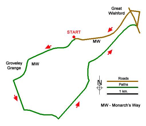
This Wiltshire walk from near Great Wishford combines areas of mature woodland with open downs. The undulating route follows good paths and bridleways and includes a section of the Monarch's Way. Refreshments are available in the attractive village of Great Wishford towards the end of the walk.
The start is the small free car park at the top of Groveley Road about two kilometres southwest of Great Wishford (grid ref. SU062347). (Limited on street parking is also available in Great Wishford.) After parking continue ahead on the clear track into woodland. You are now following a section of the Monarch's Way. Continue ahead through Groveley Wood following trail to reach a cross track on the edge of open fields. Cross straight over and continue past Groveley Grange on your right.
Follow the Monarch's Way into woodland and keep right at the first junction after entering trees. Continue ahead to reach Groveley Farm (grid ref. SU044335). Turn left, leaving the Monarch's Way, along the edge of the wood (on your left). Continue ahead soon passing through trees. After exiting the wood, maintain direction across a field to reach the Ox Drove (grid ref. SU047327). Turn left and continue along the clear track. The track soon becomes a narrow tarmac lane, which is followed until the lane bends right (grid ref. SU569324).
At this point turn left onto a grassy track to the left of a milestone. Follow the enclosed path for a kilometre top reach woodland. Continue ahead through Groveley Wood. Go straight across First Broad Drive (grid ref. SU065377) and continue through the wood to exit onto downland. Continue ahead following the track as it bends right to pass under the railway and reach a road (grid ref. SU080351).
Turn left and almost immediately fork right along South Street. Continue to the parish church. Just before the church bear left and continue to a T-junction. Turn left along West Street, rejoining the Monarch's Way. Reaching The Royal Oak, continue ahead with pub on your right, pass under the railway and continue up the lane back to start.
Messaging & Social Media
Message Walking Britain and follow the latest news.

Mountain Weather
Stay safe on the mountains with detailed weather forecasts - for iOS devices or for Android devices.