Brecon Beacons Horseshoe from Taf Fechan Forest
Brecon Beacons/Bannau Brycheiniog Walk
Nat Park - Brecon Beacons - Brecon Beacons Central
County/Area - Powys
Author - Lou Johnson
Length - 8.5 miles / 13.8 km Ascent - 2115 feet / 641 metres
Time - 6 hours 20 minutes Grade - moderate
Maps 

| Ordnance Survey Explorer OL12 | Sheet Map | 1:25k | BUY |
| Anquet OS Explorer OL12 | Digital Map | 1:25k | BUY |
| Ordnance Survey Landranger 160 | Sheet Map | 1:50k | BUY |
| Anquet OS Landranger 160 | Digital Map | 1:50k | BUY |
Walk Route Description
Click image to visit gallery of 3 images.
This is an ideal walk for those wanting an introduction to the highest land in the Brecon Beacons and uses a relatively unfrequented approach to Pen y Fan avoiding most of the crowds trudging up from Storey Arms on the A470 Merthyr to Brecon road. The drive in contrasts to the idea that this area is heavily urbanised.
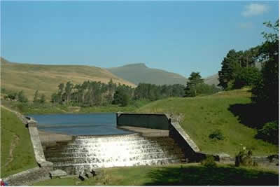
From the main A465 (Heads of the Valleys road) at Merthyr Tydfil we took the road on the west side of the Pontsticill Reservoir into the Taf Fechan Forest. Turning off towards the Upper Neuadd Reservoir we parked at grid ref. SO035173 where there is adequate parking. This was probably one of the sunniest days of the year yet parking was relatively easy.
After parking your car, walk north along the lane to the Filter House and head west across the abandoned dam wall. Cross into open country and climb steeply up the north side of the plantation to gain the edge just north of the 642m. triangulation point. Turning north along the edge you can set a cracking pace. To your right is the Upper Neuadd Reservoir whilst ahead lie the summits, which are your objectives for your walk.
The edge walk is reminiscent of the Kinder Plateau although the red sandstone is unfamiliar and provides a pleasant change to the gritstone of the more northerly upland areas of England. After walking along the top of the cliffs of Graig Fan Ddu you reach a nice section where the ridge narrows offering good views to your left into Nant Crew.
Corn Du is the first summit to be topped and this is an easy proposition offering excellent views in all directions particularly to the north to Brecon and the rolling hills of Central Wales. It is only now that you are able to inspect the steep escarpments that face north. Partly grassed these steep cliffs fall over one thousand feet to the u-shaped valleys below. Also evident are the excellent approaches from the north along the ridges separating the valleys.
Pen y Fan (2906 ft./ 886 m.) is the highest point in South Wales and therefore the Brecon Beacons National Park. It is only a short easy walk from Corn Du and provides an excellent viewpoint east along the escarpment. Easy access from Storey Arms makes it a popular excursion and unless the weather is bad you can not expect to have the summit to yourself.
Although the going is not hard there are some steep ascents and descents made more tiring by the lack of immediate interest underfoot. From Pen y Fan continue along the escarpment edge to Cribyn the next summit on the round. Reaching Bwlch ar y Fan you have a choice. If time and energy permit you can make the 500 foot climb to the summit of Fan y Big or follow the easily graded path south to the starting point of the walk.
Other walks nearby
| Walk 1552 | Waun Rydd | easy/mod | 5.5 miles |
| Walk 1283 | Fan y Big from Torpantau | moderate | 8.5 miles |
| Walk 2349 | Pen Y Fan & Corn Du from near Storey Arms | moderate | 4.6 miles |
| Walk 3616 | Fan Fawr from Storey Arms | moderate | 6.0 miles |
| Walk 2400 | Pen y Fan from Cwmgwdi near Brecon | moderate | 5.0 miles |
| Walk 1903 | Pen y Fan & Corn Du from Cwmgwdi | moderate | 7.5 miles |
| Walk 2074 | Highest Peaks of the Brecon Beacons | mod/hard | 11.0 miles |
| Walk 2641 | Fan Fawr & Fan Frynych, Fforest Fawr | moderate | 6.5 miles |
| Walk 2648 | The Black Mountain, Brecon Beacons | moderate | 8.0 miles |
| Walk 3546 | Pen y Bryn from Pencelli | moderate | 5.0 miles |
Recommended Books & eBooks
Walking on the Brecon Beacons
 45 circular day walks are described in this guidebook to the Brecon Beacons National Park. From west to east, Mynydd Du, Fforest Fawr, the Brecon Beacons and the Black Mountains these mountain and valley routes offer many options, highlighting the natural features. The walks described explore dramatic waterfalls, wooded gorges and upland valleys.
More information
The Cambrian Way
 Guidebook to the Cambrian Way, a challenging three-week mountain trek through Wales from Cardiff to Conwy. The 470km un-waymarked route is presented from south to north. Often sticking to long, beautiful ridgelines, it crosses wild and rugged terrain and visits many of Wales's highest mountains, including Snowdon.
More information
Messaging & Social Media
Message Walking Britain and follow the latest news.

Mountain Weather
Stay safe on the mountains with detailed weather forecasts - for iOS devices or for Android devices.