Black Hag from Kirk Yetholm
Northumberland Walk
Nat Park - Northumberland
County/Area - Scottish Borders
Author - Lou Johnson
Length - 8.5 miles / 13.8 km Ascent - 2110 feet / 639 metres
Time - 6 hours 20 minutes Grade - moderate
Maps 

| Ordnance Survey Explorer OL16 | Sheet Map | 1:25k | BUY |
| Anquet OS Explorer OL16 | Digital Map | 1:25k | BUY |
| Ordnance Survey Landranger 74 | Sheet Map | 1:50k | BUY |
| Anquet OS Landranger 74 | Digital Map | 1:50k | BUY |
Walk Route Description
Click image to visit gallery of 5 images.
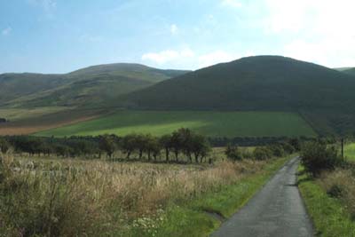
For completeness this walk starts in the village of Kirk Yetholm the northern terminus of the Pennine Way. It combines the high and low level alternative routes for the first (or final) section of this long distance footpath. Despite being very close to England (on the other side of the fence) for some of the way this route stays on Scottish territory for its full length. Ensure you take adequate clothing as there is little shelter along this walk.
Ample parking is available around the pleasant village green in Kirk Yetholm (grid ref NT827282). Take the lane signed to Halterburn climbing out of the village. The lane then descends to a cattle grid where a finger post defines the onward route of the Pennine Way across a footbridge over Halter Burn. The path climbs across the flanks of Green Humbleton to reach the border fence near Stob Rig.
Turn south following the border fence to climb to Whitelaw Nick. From here you get a clear view forward and you realise the terrain is not as easy as you may have imagined. In fact anyone tempted to walk the Pennine Way is well advised to try this walk as it offers a short but valuable insight into the levels of fitness required on this northern section of the path. An unwelcome descent from the Nick is followed by a long steady climb to the summit of Black Hag which is just off the Pennine Way. The summit itself is not very inspiring but there is a fine view into Northumberland as well as a good retrospective of the route covered so far.
Retrace your steps and locate the junction of the high and low level (or good and bad weather!) alternative routes. Take the left fork - a track rather than a path - which descends towards the north. Height is soon lost and you reach Birky Knowe where a finger post provides guidance on the onward route of the path across fields. The lack of path erosion is indicative of the low numbers of people walking this way and solitude is one of the great aspects of walking in this part of Britain. Follow the path past the abandoned farmstead of Old Halterburnhead, which offers the only shelter on this walk, and continue down the valley to reach the cattle grid crossed earlier in the day. All that remains is a final uphill pull along the lane before the village of Kirk Yetholm comes into view.
Other walks nearby
| Walk 3296 | Grubbit Law & Hownam Law from Morebattle | moderate | 7.0 miles |
| Walk 1314 | Great Hetha and Elsdon Burn from Hethpool | easy/mod | 4.0 miles |
| Walk 3644 | Blackhaggs Rigg & Great Hetha from Hethpool | moderate | 9.6 miles |
| Walk 3646 | Hethpool, Sutherland Bridge & Great Hetha | moderate | 6.0 miles |
| Walk 3739 | Elsdonburn & Trowupburn from Hethpool | moderate | 8.2 miles |
| Walk 2299 | The Cheviot | moderate | 9.0 miles |
| Walk 1894 | Burnhope Reservoir Circular | easy | 2.8 miles |
| Walk 1764 | The Cheviot from Langleeford | mod/hard | 8.2 miles |
| Walk 1765 | Comb Fell & Hedgehope Hill from Langleeford | mod/hard | 8.9 miles |
| Walk 1776 | The Cheviot & Auchope Cairn from Langleeford | mod/hard | 10.0 miles |
Recommended Books & eBooks
The Pennine Way
 Guidebook to the Pennine Way National Trail with OS map booklet. The 265 mile route from Edale to Kirk Yetholm takes three weeks to walk and is suitable for fit and experienced long distance walkers. The route crosses the Peak District, Yorkshire Dales and North Pennines National Parks. Includes separate OS 1:25,000 map booklet of the route.
More information
Walking in the Southern Uplands
 Guidebook to 44 varied day walks and over 100 summits in the Southern Uplands of Scotland, stretching south-west from Edinburgh to the English border, including the Galloway and Pentland Hills. Between 2 and 29km, there is something for all seasons and all abilities in remote and rugged hill country.
More information
Messaging & Social Media
Message Walking Britain and follow the latest news.

Mountain Weather
Stay safe on the mountains with detailed weather forecasts - for iOS devices or for Android devices.