The Tyndale Monument from Wotton-under-Edge
Cotswolds Walk
Region - Cotswolds
County/Area - Gloucestershire
Author - Lou Johnson
Length - 5.5 miles / 8.9 km Ascent - 750 feet / 227 metres
Time - 3 hours 30 minutes Grade - easy/mod
Maps 

| Ordnance Survey Explorer 167 | Sheet Map | 1:25k | BUY |
| Anquet OS Explorer 167 | Digital Map | 1:25k | BUY |
| Ordnance Survey Landranger 162 | Sheet Map | 1:50k | BUY |
| Anquet OS Landranger 162 | Digital Map | 1:50k | BUY |
Walk Route Description
Click image to visit gallery of 3 images.
The Cotswolds offer a glorious mixture of countryside that is often quoted as being 'typically English'. This short route offers expansive views south to Bristol and west to the Welsh mountains with the added benefit of including two 'monuments'.
There are many options for parking in the village of Wotton-under-Edge (grid ref. ST755933) although parking on or near Bear Street would be an advantage. Having located the latter street, walk to the top end and turn left into Tabernacle Street. Walk to the end of the street and continue on the footpath to reach a lane. Turn right along the lane for 250 metres and go left along the signed footpath to Wotton Hill.
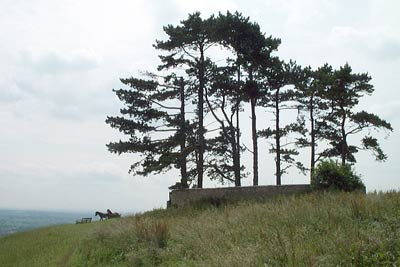
Reaching the small stand of trees planted to commemorate Queen Victoria's Golden Jubilee you are rewarded with a grand view south from the escarpment. From the walled plantation continue north to follow a waymarked path (The Cotswold Way) into Westridge Wood. The navigation on the next section can be problematic so it is recommended that you are equipped with the relevant 1:25,000 map.
On entering the wood stay on the clear track. At the next junction bear right and a short way after bear left. This leads without too many problems to Brackenbury Ditches, where the remains of an iron-age fort are in evidence. From the northern corner of the fort take the path north. You will see glimpses of the Tyndale Monument through the trees and this is your next objective.
Reaching the tower you are able to enjoy further excellent views especially to the south and west. After enjoying the prospect, walk northeast and enter the woods using the stile. Turn right along a muddy lane for a short way and then turn left down an indistinct path. This drops steeply to another stile which leads you into a field. Follow the hedge on your right and locate a stile that leads you into a lane.
Go right along the lane past Waverley Farm to reach a cross-roads. Turn right past Binley Farm and begin the climb. Passing Apple Tree Farm on your right look out for a signed bridleway on your left. This narrow path leads steeply uphill to reach a road.
Take the path opposite and continue for 300 metres. Cross the stile on your right and follow the path that contours across the flank of Coombe Hill. Keep right at the first path junction and cross a stile. A short way further you turn sharp left doubling back on yourself. Fork right and continue to descend steeply down wooden steps to a road. Turn left and take the first stile on your right to follow a path that leads back to the start.
Other walks nearby
| Walk 1877 | Uley Bury & Cam Long Down | easy/mod | 5.5 miles |
| Walk 1977 | Lasborough & Ozleworth Bottom | easy/mod | 5.8 miles |
| Walk 3437 | The Severn Estuary from Thornbury | easy/mod | 9.3 miles |
| Walk 1337 | Westonbirt Arboretum | moderate | 10.0 miles |
| Walk 1927 | Oldbury-on-Severn & Littleton-upon-Severn | easy | 5.2 miles |
| Walk 2147 | Arlington Peninsula from Saul Junction | easy/mod | 6.2 miles |
| Walk 3278 | Hinton & Dryham Circular | easy | 3.0 miles |
| Walk 3347 | Ford & North Wraxall from Castle Combe | easy/mod | 8.0 miles |
| Walk 3750 | River Severn from Arlingham | easy | 6.0 miles |
| Walk 2674 | Source of the River Thames | moderate | 11.3 miles |
Recommended Books & eBooks
The Cotswold Way
 Guidebook to walking the Cotswold Way National Trail. Between Chipping Campden and Bath, the 102 mile route explores the Cotswolds AONB. Described in both directions over 13 stages, the Cotswold Way can be walked year round and is suitable for beginner trekkers. Includes separate OS 1:25,000 map booklet of the route.
More information
The Cotswold Way Map Booklet
 Map of the 102 mile (163km) Cotswold Way National Trail, between Chipping Camden and Bath. This booklet is included with the Cicerone guidebook to the trail, and shows the full route on OS 1:25,000 maps. The trail typically takes two weeks to walk, and is suitable for walkers at all levels of experience.
More information
Messaging & Social Media
Message Walking Britain and follow the latest news.

Mountain Weather
Stay safe on the mountains with detailed weather forecasts - for iOS devices or for Android devices.