Uley Bury & Cam Long Down
Cotswolds Walk
Region - Cotswolds
County/Area - Gloucestershire
Author - Lou Johnson
Length - 5.5 miles / 8.9 km Ascent - 1000 feet / 303 metres
Time - 3 hours 50 minutes Grade - easy/mod
Maps 

| Ordnance Survey Explorer 167 | Sheet Map | 1:25k | BUY |
| Anquet OS Explorer 167 | Digital Map | 1:25k | BUY |
Walk Route Description
Click image to see photo description.
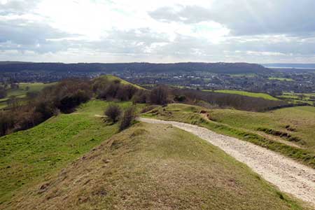
An energetic hill walk in the Cotswolds from the village of Uley. The route starts by walking up to the Uley Bury hill fort where the route continues around the ramparts. A short descent leads onto the Cotswold Way which is followed Cam Long Down for a final scend onto Cam Peak. The route returns to the start around the southern flank of Downham Hill before returning to Uley.
On street parking is available near the Green and the Old Crown pub in Uley (grid ref. ST792986). After walking walk towards the Church of St. Giles. Just before the church turn right along a tarmac path which takes round to the rear of the churchyard. After 100 metres turn and follow the path into a field. Head slightly left and continue uphill passing through trees to reach a cross path (grid ref. ST788990). Bear left and follow the path onto the ramparts.
Turn left along the ramparts and follow the path in a clockwise direction to the north-western corner of Uley Bury hill fort. Follow the path down to a small carpark and turn left past the information board to join the Cotswolds Way (grid ref. ST787994). Bear left and descend through trees to pass Hodgecombe Farm on your left. The Cotswolds Way continues to join a lane. Turn right and continue to where the lane bends right. Go through the gate ahead and continue ahead on the Cotswolds Way to cross Cam Long Down. Follow the clear path and enjoy extensive views of the surrounding countryside.
Dropping into a small valley continue ahead to make the short climb onto Cam Peak. Maintain direction down the other side. At the base of the slope turn sharp left and follow the path along the bottom of the south flank of Cam Peak Turn right onto the Cotswolds Way and drop down to Farfield Lane at Newlands (grid ref. ST771989). Turn briefly left and then right south along a signed bridleway. Continue past Coldharbour Farm and continue along the bridleway to Wresden Farm where you bear left to continue east via Newbrook Farm to a road (grid ref. ST782982).
Turn right along the road and after 250 metres fork left uphill> continue ahead between houses. Reaching the point where the road bends right, continue ahead over tarmac to join a footpath across fields. After following the right-hand side of the field for 250 metres, the path turns right and continues behind houses (on your right) to regain the path behind the church used ta the start of the walk.
Other walks nearby
| Walk 1977 | Lasborough & Ozleworth Bottom | easy/mod | 5.8 miles |
| Walk 1258 | The Tyndale Monument | easy/mod | 5.5 miles |
| Walk 2147 | Arlington Peninsula from Saul Junction | easy/mod | 6.2 miles |
| Walk 1337 | Westonbirt Arboretum | moderate | 10.0 miles |
| Walk 3750 | River Severn from Arlingham | easy | 6.0 miles |
| Walk 2674 | Source of the River Thames | moderate | 11.3 miles |
| Walk 3663 | Sudgrove & Edgeworth from Miserden | easy/mod | 6.0 miles |
| Walk 3437 | The Severn Estuary from Thornbury | easy/mod | 9.3 miles |
| Walk 1927 | Oldbury-on-Severn & Littleton-upon-Severn | easy | 5.2 miles |
| Walk 3347 | Ford & North Wraxall from Castle Combe | easy/mod | 8.0 miles |
Recommended Books & eBooks
The Cotswold Way Map Booklet
 Map of the 102 mile (163km) Cotswold Way National Trail, between Chipping Camden and Bath. This booklet is included with the Cicerone guidebook to the trail, and shows the full route on OS 1:25,000 maps. The trail typically takes two weeks to walk, and is suitable for walkers at all levels of experience.
More information
The Cotswold Way
 Guidebook to walking the Cotswold Way National Trail. Between Chipping Campden and Bath, the 102 mile route explores the Cotswolds AONB. Described in both directions over 13 stages, the Cotswold Way can be walked year round and is suitable for beginner trekkers. Includes separate OS 1:25,000 map booklet of the route.
More information
Messaging & Social Media
Message Walking Britain and follow the latest news.

Mountain Weather
Stay safe on the mountains with detailed weather forecasts - for iOS devices or for Android devices.