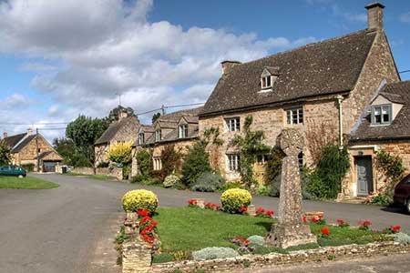
Church Westcote & Icomb Circular
Cotswolds Walk
Region - Cotswolds
County/Area - Gloucestershire
Author - Lou Johnson
Length - 5.1 miles / 8.3 km Ascent - 420 feet / 127 metres
Time - 3 hours 0 minutes Grade - easy/mod
Maps 

| Ordnance Survey Explorer OL45 | Sheet Map | 1:25k | BUY |
| Anquet OS Explorer OL45 | Digital Map | 1:25k | BUY |
Walk Route Description
Click image to see photo description.
Starting from the attractive village of Church Westcote this Cotswolds walk passes through two other villages with many buildings constructed from honey coloured local stone. The route crosses typical countryside of the area and uses a section of the Diamond Way long distance path.
There is limited parking in Church Westcote with the best option beside the parish church (grid ref. SP220205). After parking and with your back to the church, walk to the left and continue to the next road junction. Join the signed footpath on the left, which initially runs beside the road. After 150 metres veer left between trees and continue along the path through to a track in Nether Westcote (grid ref. SP225204). Follow the track to the village green. Fork left and continue past the Feathered Nest Inn on your left. Where the road bends right, join the clear track on the left. Either follow the track (a bridleway) or the path that runs parallel on the left. After just over a kilometre the Diamond Way comes in on the left.
Continue along the Diamond Way which soon forks right. The path runs inside an area of light woodland to enter fields. A clear grassy path crosses the first field to a stile in the hedge. Entering the second field, follow a clear a clear path across to a small footbridge (grid ref. SP23422). After crossing the bridge turn left briefly onto the Oxfordshire Way. Reaching a track after 120 metres, turn right and continue along the track and pass the extensive buildings of Pebbly Hill Farm. Just before a garden centre turn left onto a signed path (grid ref. SP233229). The path maintains direction across seven fields crossing two tracks along the way. The path exits onto the access drive to Middle Farm where you turn right and walk into the lovely village of Icomb with its church and stone cross.
After exploring Icomb, retrace your steps and 100 metres beyond the church turn right down a path enclosed by hedges. At the end of the enclosed section the path joins the Diamond Way and continues to pass a reservoir on your left. After crossing a field, the path enters woodland where the route heads half-right up through the trees. Exiting the woodland, the path bears half-left and continues to a path junction where the Oxfordshire Way crosses our walk. Go straight across and follow an enclosed path between hedges to enter more woodland (not shown on OS maps). The path goes half-right through the trees and exits into a field where a grassy path leads back to a track and Church Westcote. Fork left at the small green and follow to the church. Turn right into the churchyard to return to the start.
Other walks nearby
| Walk 2484 | Icomb & Wyck Rissington Circular | easy/mod | 5.2 miles |
| Walk 2076 | Kingham to Charlbury | easy/mod | 10.5 miles |
| Walk 1360 | Naunton & the Slaughters | moderate | 11.0 miles |
| Walk 2186 | Adlestrop & Chastleton | easy | 3.8 miles |
| Walk 1439 | Fulbrook & Widford | easy | 6.0 miles |
| Walk 1848 | Turkdean & Notgrove from Cold Aston | easy/mod | 6.5 miles |
| Walk 2454 | Farmington & Clapton-on-the-Hill | easy/mod | 6.4 miles |
| Walk 2168 | The Slaughters | easy/mod | 8.6 miles |
| Walk 2687 | Chadlington Circular | easy/mod | 6.3 miles |
| Walk 3636 | Bibury & Ablington Circular | easy | 4.1 miles |
Recommended Books & eBooks
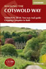
The Cotswold Way Map Booklet
 Map of the 102 mile (163km) Cotswold Way National Trail, between Chipping Camden and Bath. This booklet is included with the Cicerone guidebook to the trail, and shows the full route on OS 1:25,000 maps. The trail typically takes two weeks to walk, and is suitable for walkers at all levels of experience.
More information
The Cotswold Way
 Guidebook to walking the Cotswold Way National Trail. Between Chipping Campden and Bath, the 102 mile route explores the Cotswolds AONB. Described in both directions over 13 stages, the Cotswold Way can be walked year round and is suitable for beginner trekkers. Includes separate OS 1:25,000 map booklet of the route.
More information
Messaging & Social Media
Message Walking Britain and follow the latest news.

Mountain Weather
Stay safe on the mountains with detailed weather forecasts - for iOS devices or for Android devices.