Aqualate Mere & Sutton
Staffordshire Walk
County/Area - Staffordshire - Mid Staffordshire
Author - Lou Johnson
Length - 5.2 miles / 8.5 km Ascent - 200 feet / 61 metres
Time - 2 hours 50 minutes Grade - easy
Maps 

| Ordnance Survey Explorer 242 | Sheet Map | 1:25k | BUY |
| Anquet OS Explorer 242 | Digital Map | 1:25k | BUY |
| Ordnance Survey Explorer 243 | Sheet Map | 1:25k | BUY |
| Anquet OS Explorer 243 | Digital Map | 1:25k | BUY |
Walk Route Description
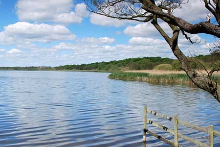
Click image to see photo description.
A walk starting from close to Aqualate Mere exploring the pleasant Staffordshire countryside to the north of the mere. The route follows field paths and bridleways, passes through the village of Sutton, and offers views across the mere.
The walk starts from the Aqualate Mere National Nature Reserve car park (grid ref. SJ788203) which can be reached from the A518 between Newport and Gnosall. After parking, walk back to Guild Lane and turn left. Stay on the lane until it bends left (grid ref. SJ785207). Continue straight ahead to join a signed bridleway. The clear track runs between hedges, briefly running beside a wood on your left to enter a field. Continue ahead over grass to join a clear track. Turn left and follow the track to reach Radmore Lane.
Turn left along Radmore Lane and continue for 800 metres to a junction where the lane bends left (grid ref. SJ777218). Walk straight ahead to join a track between hedges (Cliff's Lane). Continue ahead ignoring a footpath on the left to reach a cross track (grid ref. SJ772224). Turn left and follow the track to Guild Road in Sutton. Turn right and follow the road as it swings left. Pass a large house on the left, ignore the first signed footpath, pass another house on the left and turn left at the fingerpost (on your right). Follow the path through a yard and exit into fields. The path heads in south westerly direction across several fields and crosses the access drive to Sutton Bank Farm on your left (grid ref. SJ763217).
Once across the driveway, follow the path beside a hedge on your left. Continue into the next field and turn right and follow the right-hand field edge. Continue into the next field and head half-left to a gap in the hedge. Once in the next field, continue ahead for 100 metres and the turn right to follow a track that crosses the route of an old canal and into the next field. Follow the path through gaps in hedges to the far end of the field. Pass through a gap in the hedge and turn left and continue to a group of trees beside a track. Turn right along the track. The right of way heads across fields with occasional waymarks and marker posts. Pass through a gate (grid ref. SJ770210) and follow a grassy track with woodland on your left. At the end of the wood maintain direction and follow path across fields to enter woodland on your right (grid ref. SJ777207). Stay on the path through woodland. There is a path off to the right to a hide from where you can obtain a good view of Aqualate Mere. The path exits the wood and runs along the edge of the wood back to the start.
Other walks nearby
| Walk 1941 | Outwoods & Beffcote | easy | 4.1 miles |
| Walk 2499 | Aqualate Mere & Forton | easy/mod | 8.0 miles |
| Walk 1837 | Norbury Junction Circular | easy | 4.6 miles |
| Walk 2269 | Norbury Junction, Gnosall & Aqualate Mere | easy/mod | 8.1 miles |
| Walk 3531 | Cop Mere and the Offleys | easy | 7.0 miles |
| Walk 3591 | Derrington circular from Stafford Castle | easy | 3.6 miles |
| Walk 2099 | Stafford - a town centre stroll | easy | 1.5 miles |
| Walk 1394 | Bednall & Acton Trussell from near Stafford | easy | 6.5 miles |
| Walk 2500 | Chillington Hall & Shropshire Union Canal from Brewood | easy | 6.0 miles |
| Walk 2199 | Brocton & Walton-on-the-Hill Circular | easy | 3.5 miles |
Recommended Books & eBooks
Walking in the Peak District - White Peak East
 Guidebook describing 42 half-day and day walks in the limestone landscapes of Derbyshire's White Peak, part of the Peak District National Park. One of two volumes, this book covers the east of the region, with potential bases including Bakewell, Eyam, Castleton, Birchover, Matlock and Wirksworth.
More information
Messaging & Social Media
Message Walking Britain and follow the latest news.

Mountain Weather
Stay safe on the mountains with detailed weather forecasts - for iOS devices or for Android devices.