Walk 2353 - printer friendly version
Aqualate Mere & Sutton Walk
Author - Lou Johnson
Length - 5.2 miles / 8.5 km
Ascent - 200 feet / 61 metres
Grade - easy
Start - OS grid reference SJ788203
Lat 52.7798610 + Long -2.3157326
Postcode TF10 9DE (approx. location only)
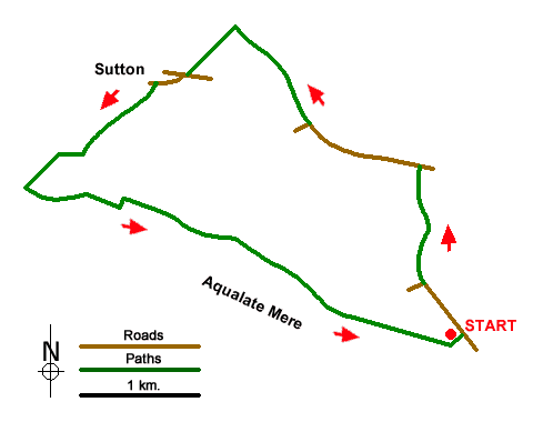
A walk starting from close to Aqualate Mere exploring the pleasant Staffordshire countryside to the north of the mere. The route follows field paths and bridleways, passes through the village of Sutton, and offers views across the mere.
The walk starts from the Aqualate Mere National Nature Reserve car park (grid ref. SJ788203) which can be reached from the A518 between Newport and Gnosall. After parking, walk back to Guild Lane and turn left. Stay on the lane until it bends left (grid ref. SJ785207). Continue straight ahead to join a signed bridleway. The clear track runs between hedges, briefly running beside a wood on your left to enter a field. Continue ahead over grass to join a clear track. Turn left and follow the track to reach Radmore Lane.
Turn left along Radmore Lane and continue for 800 metres to a junction where the lane bends left (grid ref. SJ777218). Walk straight ahead to join a track between hedges (Cliff's Lane). Continue ahead ignoring a footpath on the left to reach a cross track (grid ref. SJ772224). Turn left and follow the track to Guild Road in Sutton. Turn right and follow the road as it swings left. Pass a large house on the left, ignore the first signed footpath, pass another house on the left and turn left at the fingerpost (on your right). Follow the path through a yard and exit into fields. The path heads in south westerly direction across several fields and crosses the access drive to Sutton Bank Farm on your left (grid ref. SJ763217).
Once across the driveway, follow the path beside a hedge on your left. Continue into the next field and turn right and follow the right-hand field edge. Continue into the next field and head half-left to a gap in the hedge. Once in the next field, continue ahead for 100 metres and the turn right to follow a track that crosses the route of an old canal and into the next field. Follow the path through gaps in hedges to the far end of the field. Pass through a gap in the hedge and turn left and continue to a group of trees beside a track. Turn right along the track. The right of way heads across fields with occasional waymarks and marker posts. Pass through a gate (grid ref. SJ770210) and follow a grassy track with woodland on your left. At the end of the wood maintain direction and follow path across fields to enter woodland on your right (grid ref. SJ777207). Stay on the path through woodland. There is a path off to the right to a hide from where you can obtain a good view of Aqualate Mere. The path exits the wood and runs along the edge of the wood back to the start.
Messaging & Social Media
Message Walking Britain and follow the latest news.

Mountain Weather
Stay safe on the mountains with detailed weather forecasts - for iOS devices or for Android devices.