The Dyfi Hills Ridge
Hill Walk + Ridge Walk + Waterfall
Nat Park - Snowdonia - Cadair Idris
County/Area - Gwynedd
Author - Lou Johnson
Length - 9.8 miles / 15.9 km Ascent - 2500 feet / 758 metres
Time - 7 hours 20 minutes Grade - mod/hard
Maps 

| Ordnance Survey Explorer OL23 | Sheet Map | 1:25k | BUY |
| Anquet OS Explorer OL23 | Digital Map | 1:25k | BUY |
Walk Route Description
Click image to see photo description.
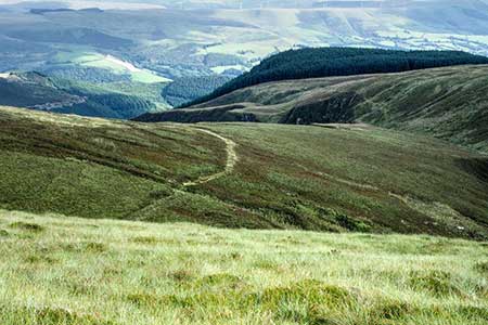
A linear ridge walk over the Dyfi Hills. The route lacks clear paths in parts and the relevant OS map is useful. The walk crosses a succession of summits over 600 metres including Waun-oer, Craig Portas and impressive Maen Du. Throughout the walk there are excellent views across a sea of hills and you are unlikely to be disturbed by other walkers.
The start is a parking area on the A487 (grid ref. SH753136) about three kilometres south from the junction with the A470 by the Cross Foxes. This parking area can be busy with aircraft enthusiasts as it is close to a Mach Loop viewing point. After parking walk uphill using the grass verge where possible. Cross the first ladder stile on the right to join the Cambrian Way. The path is indistinct in places but initially climbs up through rocky ground before crossing open hillside to reach a track (grid ref. SH760138). Cross the track and head uphill. There is a path of sorts and if in doubt keeping heading uphill to reach the ridge of Mynydd Ceiswyn. Reaching a fence, turn left and follow the rising path up the ridge with the fence on your right. Cross the summit and after a short descent stay with the fence to the summit of Waun-oer from where there is an excellent view to Cadair Idris.
Continue with the fence right and descend steeply into a col. Climb out the other side to turn left over a stile to stay with the Cambrian Way. The onward route continues now with the fence on your left. Another stile and the next objective Craig Portas is a short distance ahead. The summit is superb with steep slopes, especially to the north. The route continues eat with steep slopes on your left and a fence on your right. Cross a section of duckboards and continue beside the fence when it bends left and then right. Cross a stile and continue to the summit of Maen Du from where you can enjoy a view to the Arans.
Leave the summit and head southeast onto Maesglase with steep slopes drooping into Cwm yr Eglwys. A grassy path heads south along the edge of the crags. Just before reaching a stream, a pinnacle offers a superb view of Maesglase Falls. On the next section stay with the Cambrian Way, which veers away from the edge and heads towards a plantation. Reaching the trees the path bears left with a fence on your right. After 400 metres leave the Cambrian Way and bear left down a steep slope. The path zigzags down the hillside and fades in a few places. The path passes through the remains of mining activity to join and improving grassy track that heads down the valley to join a lane.
Turn right and continue to the A470. Here you have two options. You can head down the A470 into Dinas Mawddwy which can see heavy traffic. In my view the better option is to turn right along the A470 and take the first road on the left This drops down to cross the Nant Maesglase. Fork right after the bridge and at the next junction fork right again. Follow a track across the hillside and into trees. Just after an opening in the trees on your eight, turn right onto a footpath that passes through a caravan site on your right. Exit to the road and turn right in Dinas Mawddwy and the car park (grid ref. SH858150).
Other walks nearby
| Walk 1204 | Cadair Idris Minffordd Path | mod/hard | 6.0 miles |
| Walk 2100 | Circuit of Cadair Idris from Minffordd | mod/hard | 11.0 miles |
| Walk 2334 | The Torrent Walk near Dolgellau | easy | 1.6 miles |
| Walk 1172 | Cadair Idris by the Pony Path | mod/hard | 11.0 miles |
| Walk 2668 | Cadair Idris, Craig Cau and Cyfrwy by the Pony Path | mod/hard | 5.3 miles |
| Walk 1107 | Waun Oer and Maesglase near Dinas Mawddwy | mod/hard | 11.0 miles |
| Walk 1646 | The Precipice Walk | easy | 3.5 miles |
| Walk 2570 | Cadair Idris from Llanfihangel-y-pennant | mod/hard | 10.0 miles |
| Walk 2707 | Tyrrau Mawr and Craig-y-llyn from Llanfihangel-y-pennant | moderate | 9.5 miles |
| Walk 1851 | Cregennen Lakes & Pared y Cefn-hir | easy/mod | 2.5 miles |
Recommended Books & eBooks
Great Mountain Days in Snowdonia
 Inspirational guidebook to 40 great mountain day walks and scrambles in Snowdonia. Inspirational routes for all abilities across the National Park with routes up Snowdon and Moel Eilio, the Glyderau, the Carneddau, Eifionydd, Siabod and the Moelwynion, Rhinogydd (the Harlech Dome), Migneint and the Arans and Cadair Idris and the Tarrens.
More information
The Cambrian Way
 Guidebook to the Cambrian Way, a challenging three-week mountain trek through Wales from Cardiff to Conwy. The 470km un-waymarked route is presented from south to north. Often sticking to long, beautiful ridgelines, it crosses wild and rugged terrain and visits many of Wales's highest mountains, including Snowdon.
More information
Messaging & Social Media
Message Walking Britain and follow the latest news.

Mountain Weather
Stay safe on the mountains with detailed weather forecasts - for iOS devices or for Android devices.