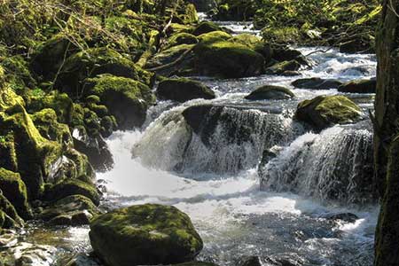
The Torrent Walk near Dolgellau
Snowdonia/Eryri Walk
Nat Park - Snowdonia - Cadair Idris
County/Area - Gwynedd
Author - Lou Johnson
Length - 1.6 miles / 2.6 km Ascent - 380 feet / 115 metres
Time - 1 hours 10 minutes Grade - easy
Maps 

| Ordnance Survey Explorer OL23 | Sheet Map | 1:25k | BUY |
| Anquet OS Explorer OL23 | Digital Map | 1:25k | BUY |
Walk Route Description
Click image to see photo description.
This short walk follows the Afon Clywedog downstream as it is passes over a string of pretty waterfalls. The route is easy to follow along a waymarked path. As you descend side paths take you closet to the river where the falls are particularly impressive. The route can be reached by taking the A470 from Dolgellau and turning left onto the B4416 signed to Brithdir. This walk could also be combined with the Precipice Walk nearby.
There are two laybys on either side of the close to the start of the walk about 500 metres after leaving the A470 (grid ref. SH761181). There is a fingerpost adjacent to the layby on the north side of the road. After parking walk to the fingerpost and continue towards Dolgellau beside the crash barrier. Turn right down to a metal kissing gate at the fingerpost. The path descends to a bridge across the river and then continues down through woodland running roughly parallel to the river.
As you proceed there are many side paths to the right leading to the best vantage spots to view the cascades. It is probably best to time your visit after a period of heavy rain as when the river is in spate the falls become very dramatic. Eventually the path finishes at a minor road. From here reverse the route back up the path. It is surprising how much you missed during the descent!
Other walks nearby
| Walk 1646 | The Precipice Walk | easy | 3.5 miles |
| Walk 1107 | Waun Oer and Maesglase near Dinas Mawddwy | mod/hard | 11.0 miles |
| Walk 2475 | The Dyfi Hills Ridge | mod/hard | 9.8 miles |
| Walk 2551 | Rhobell Fawr from near Rhydymain | moderate | 5.7 miles |
| Walk 2811 | Rhobell Fawr and Ddualt from near Rhydymain | moderate | 8.5 miles |
| Walk 1499 | Rhobell Fawr and Dduallt from Llanfachreth | moderate | 12.0 miles |
| Walk 2937 | Aran Fawddwy northern approach | mod/hard | 8.4 miles |
| Walk 1172 | Cadair Idris by the Pony Path | mod/hard | 11.0 miles |
| Walk 2668 | Cadair Idris, Craig Cau and Cyfrwy by the Pony Path | mod/hard | 5.3 miles |
| Walk 1204 | Cadair Idris Minffordd Path | mod/hard | 6.0 miles |
Recommended Books & eBooks
Mountain Walking in Snowdonia
 Guidebook to 40 of Snowdonia's best day walks, with routes up Snowdon and Tryfan, including the Snowdon Horseshoe, Cadair Idris, Y Garn and The Rhinogs. The routes range from Grade 1 scrambles like Crib Goch or Bristly Ridge, to riverside and forest walks. Includes details of a 2-day traverse of all 15 of Snowdonia's 3000ft peaks.
More information
The Cambrian Way
 Guidebook to the Cambrian Way, a challenging three-week mountain trek through Wales from Cardiff to Conwy. The 470km un-waymarked route is presented from south to north. Often sticking to long, beautiful ridgelines, it crosses wild and rugged terrain and visits many of Wales's highest mountains, including Snowdon.
More information
Messaging & Social Media
Message Walking Britain and follow the latest news.

Mountain Weather
Stay safe on the mountains with detailed weather forecasts - for iOS devices or for Android devices.