Holy Island - Lindisfarne Castle & Emmanuel Head
Northumberland County Walk
County/Area - Northumberland County
Author - Lou Johnson
Length - 4.4 miles / 7.2 km Ascent - 150 feet / 45 metres
Time - 2 hours 20 minutes Grade - easy
Maps 

| Ordnance Survey Explorer 340 | Sheet Map | 1:25k | BUY |
| Anquet OS Explorer 340 | Digital Map | 1:25k | BUY |
Walk Route Description
Click image to visit gallery of 8 images.
Holy Island, or Lindisfarne, lies off the Northumberland coast. The island has many historic and religious connections with many tourists in season. In addition, Holy Island sees many species of birds throughout the year attracting many ornithologists. Despite the number of visitors to the island, it is possible to enjoy some solitude and this walk does just that visiting the east coast and the dunes in the north.
Careful planning is required before making a visit. Holy Island is cut off from the mainland at high tide so ideally you should arrive just as the road becomes passable on a falling tide. This walk, allowing for some leisurely exploration of the village, takes about three hours. If in doubt do not start the walk as the alternative is being stranded on the island!
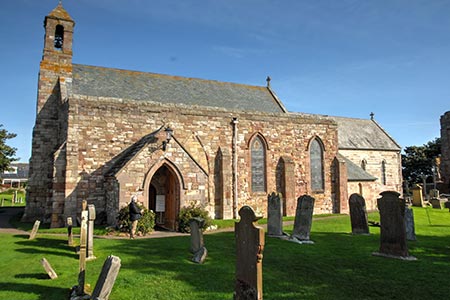
After crossing the causeway, you reach a large pay and display car-park on the left (grid ref. NU125423). This is as convenient as the other car park in the village. After parking follow the road into the village and continue to the parish church. The church is adjacent to the ruined Priory for which admission charges apply. Visiting the church and churchyard is free. Continue through the churchyard and exit via the gate to the west of the church. Turn left and follow the path which soon crosses a small rocky outcrop offering a good view south to Bamburgh Castle.
Descend to follow a track between upturned hulls now used for storage. Bear right onto the tarmac access drive to Lindisfarne Castle. Just prior to the castle the lane forks. Keep left here and continue along the northern flank of the castle. The tarmac ends and becomes a clear track which is followed to reach the eastern shore of the island. Turn left along the coast following the path nearest the sea. Ahead you will see the white triangular landmark at Emmanuel Head which is the next objective. The landmark has the benefit of some wooden benches you wish to linger and enjoy the views and solitude.
To continue, walk east following paths on the dunes. There are many possible routes but I found the best option was stay as high as possible keeping to a sandy 'ridge' for just over 600 metres. With the benefit of height, you can see the sign at the end of the enclosed lane at grid ref. NU129432. Using one of the many paths through the sandy landscape this was soon reached. Once at the end of the lane, walk south back into the village passing St Combs farm on the left. To reach the large car park, take the next right passing the coach park (on your right). Reaching the main road into the village, turn right again and the car park is a short up this road on the right.
Other walks nearby
| Walk 2738 | Budle Bay from Bamburgh | easy | 4.0 miles |
| Walk 3522 | Bamburgh Castle circular | easy/mod | 7.5 miles |
| Walk 2677 | Circuit of Doddington Moor | easy | 3.8 miles |
| Walk 2282 | Bewick Moor | moderate | 9.1 miles |
| Walk 1199 | Dunstanburgh Castle | easy | 4.5 miles |
| Walk 3335 | Howick & Cullernose Point | easy | 4.5 miles |
| Walk 2397 | Beadnell to Craster | easy/mod | 7.9 miles |
| Walk 1764 | The Cheviot from Langleeford | mod/hard | 8.2 miles |
| Walk 1765 | Comb Fell & Hedgehope Hill from Langleeford | mod/hard | 8.9 miles |
| Walk 1776 | The Cheviot & Auchope Cairn from Langleeford | mod/hard | 10.0 miles |
Recommended Books & eBooks
Hadrian's Wall Path
 Hadrians Wall Path guidebook to walk the 84 mile National Trail. Described in both directions, the main description is west to east between Bowness-on-Solway and Wallsend, Newcastle, with extensions to Maryport and South Shields. With extensive historical information related to this World Heritage site and separate 1:25,000 OS map booklet included.
More information
Walking in Northumberland
 This guidebook contains detailed route descriptions for 36 day walks in Northumberland including the Cheviot Hills. The terrain varies from wild walks and craggy ascents to gentle riverside strolls. Each route ranges from 4 to 16 miles in length and there is the opportunity to link several walks together to create longer treks.
More information
Messaging & Social Media
Message Walking Britain and follow the latest news.

Mountain Weather
Stay safe on the mountains with detailed weather forecasts - for iOS devices or for Android devices.