Bradford & Lathkill Dales from Monyash
Peak District Walk
Nat Park - Peak District - Lathkill Dale High Peak
County/Area - Derbyshire
Author - Lou Johnson
Length - 11.3 miles / 18.3 km Ascent - 875 feet / 265 metres
Time - 6 hours 30 minutes Grade - moderate
Maps 

| Ordnance Survey Explorer OL24 | Sheet Map | 1:25k | BUY |
| Anquet OS Explorer OL24 | Digital Map | 1:25k | BUY |
| Ordnance Survey Landranger 119 | Sheet Map | 1:50k | BUY |
| Anquet OS Landranger 119 | Digital Map | 1:50k | BUY |
Walk Route Description
Click image to visit gallery of 3 images.
Monyash, just to the east of the main Ashbourne to Buxton road, is a typical village of the White Peak. Clustered around the church, the stone built-cottages and farms still form a viable community even though the role of the village has changed dramatically in the last half century. There is a small car-park (grid ref. SK 149666) with additional limited on-street parking. With two cafes and a pub refreshments are normally available. A shorter alternative is Walk 3046 which also includes further illustrations.
Providing varied scenery throughout, this Peak District walk is a popular excursion. On fine days the paths can be busy although most people will be enjoying shorter excursions than the route described.
From the cross-roads in the centre of the village take the road south quickly turning left along the "Limestone Way" across fields to One Ash Grange Farm. The path leads down the left hand side of the farm to drop down steeply into the bottom of Cales Dale. You now have your first sight of the upper reaches of Lathkill Dale which you will see in more detail on the return leg of the walk.
From the depths of Cales Dale, climb the steep steps as you make for Calling Low where the footpath has been diverted from its original route. With the steepest climb behind you good speed can be maintained for the rest of the walk. Continuing on the "Limestone Way" make for the eastern corner of Low Moor Plantation and make for the car park and picnic area just off the Conksbury road.
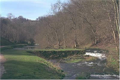
The only part of the walk that needs any map reading skills now follows. You need to descend into Bradford Dale by using the footpaths and road to reach Lomberdale Hall. Follow the road towards Middleton as far as the sharp bend and then take the path down to the weir. Cross the river and walk east towards Alport passing attractive pools as you progress downstream.
Above the valley on your left is the village of Youlgreave worth exploring if you have time and energy. Stay with the river, keeping on the south bank, all the way down Bradford Dale to Alport, a small village worth a few minutes exploration. The route now continues along Lathkill Dale. There are three distinct sections to the dale. On the first section as far as Conksbury Bridge you stay on the west bank of the river crossing fields in a wide valley. From Conksbury Bridge onwards you stay on the north bank and enter the second of the distinct sections of the Dale.
In complete contrast to the lower section, the dale suddenly becomes wooded and narrows. As in Bradford Dale there are pools contained behind a series of weirs. Used to the open landscapes of moor and mountain, I find this section quite claustrophobic but it is easy walking and the deciduous woods make a nice change from dark regimented conifers.
Suddenly you reach the final section of the dale with limestone outcrops replacing the wooded slopes. This is the most dramatic section of the walk and you soon reach the foot of Cales Dale which you crossed earlier in the day. The Dale narrows and you will note the stream appearing from a cave on your left (grid ref. 173656). You are now walking in a dry valley so typical of limestone country in many parts of Britain. Gradually the valley becomes shallower until you emerge into fields and reach the main road. Turn left into the village and within a few minutes you are back at your car.
Other walks nearby
| Walk 3709 | Sparklow, Crowdicote & Pilsbury Circular | easy/mod | 9.0 miles |
| Walk 1206 | Chelmorton & Flagg from Taddington | easy/mod | 6.0 miles |
| Walk 1651 | Monsal Trail & Ashford-in-the-Water from Lees Bottom | easy/mod | 8.8 miles |
| Walk 3341 | Brushfield, Miller's Dale & Monsal Head from Lees Bottom | easy/mod | 6.5 miles |
| Walk 1569 | Lathkill Dale & Bradford Dale | easy/mod | 8.2 miles |
| Walk 1589 | Lathkill & Bradford Dales (short version) | easy/mod | 6.0 miles |
| Walk 1590 | Monyash & Lathkill Dale | easy/mod | 8.2 miles |
| Walk 1043 | Chelmorton & the Monsal Trail | easy/mod | 8.1 miles |
| Walk 1945 | Lathkill Dale & Over Haddon circular | easy/mod | 5.7 miles |
| Walk 1369 | Tissington Trail - Hartington to Parsley Hey | easy | 4.0 miles |
Recommended Books & eBooks
Walking in the Peak District - White Peak East
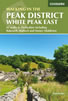 Guidebook describing 42 half-day and day walks in the limestone landscapes of Derbyshire's White Peak, part of the Peak District National Park. One of two volumes, this book covers the east of the region, with potential bases including Bakewell, Eyam, Castleton, Birchover, Matlock and Wirksworth.
More information
Walking in Derbyshire
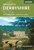 Walking guidebook to 60 circular day walks in Derbyshire and the Peak District. Includes the Derwent, Wye and Trent river valleys, near Derby, Matlock, Glossop, Bakewell and Ripley. Routes range from easy to moderate and are between 4 and 14km (2 to 10 miles). Walks focus on places of interest, from Stone Age forts to castles to grand estates.
More information
Messaging & Social Media
Message Walking Britain and follow the latest news.

Mountain Weather
Stay safe on the mountains with detailed weather forecasts - for iOS devices or for Android devices.