Monsal Trail & Ashford-in-the-Water from Lees Bottom
Peak District Walk
Nat Park - Peak District - Bakewell Monsal Trail
County/Area - Derbyshire
Author - Lou Johnson
Length - 8.8 miles / 14.2 km Ascent - 1000 feet / 303 metres
Time - 5 hours 20 minutes Grade - easy/mod
Maps 

| Ordnance Survey Explorer OL24 | Sheet Map | 1:25k | BUY |
| Anquet OS Explorer OL24 | Digital Map | 1:25k | BUY |
| Ordnance Survey Landranger 119 | Sheet Map | 1:50k | BUY |
| Anquet OS Landranger 119 | Digital Map | 1:50k | BUY |
Walk Route Description
Click image to see photo description.
For the most part this Peak District walk follows well used paths and trails. Do remember that there is a lengthy ascent towards the end of the route through Great Shacklow Wood. The start is the pay and display car park at Lees Bottom (grid ref. SK170706) where there are also public toilets. Refreshments can be obtained at Monsal Head and in the village of Ashford-in-the-Water.
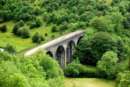
Exit the carpark onto the A6 main road. Cross over to the signed path, descend the awkward stile and follow into the woodland. Where the path splits keep right and continue down to the River Wye. Follow this pleasant path upstream through Monsal Dale. Just before the old railway viaduct turn left and climb up to the old railway track. Turn right and cross the viaduct. Then take the path on the left that climbs up to Monsal Head with its wonderful views across the dale and railway viaduct.
From the road junction at Monsal Head take the lane towards Little Longstone. Take the first footpath on your right opposite the chapel (grid ref. SK187716). Continue along this path to turn left onto the Monsal Trail. There follows a section of easy walking going past Thornbridge Hall on your right to cross the A6020. About three metres further on descend to the walled lane and walk south (grid ref. SK213707). Continue on this bridleway across Cracknowl to reach the River Wye. Cross the river and walk up to the A6. Turn right along the A6 passing Lumford Mill on your right. At grid ref. SK209690) take the footpath on your right. This path loops along beside the River Wye before returning to the A6.
Turn right along the A6 cross the old bridge over the River Wye and walk into the centre of Ashford-in-the-Water. Turn left down Greaves Lane, Left again into Church Street, continuing to cross the bridge on your right over the River Wye to the A6. Turn right along the A6, taking the lane on your left (signed to Sheldon). Where the road bends to the left, go straight ahead onto the signed footpath at grid ref. SK189694. This path leads alongside the River Wye. Ignore paths off to your left and continue straight ahead. You will enter Great Shacklow Wood. Initially the path stays by the river but eventually climbs steadily through the wood. Reaching a steep open field at the end of the wood, turn right and descend back to the start.
Other walks nearby
| Walk 1827 | Ashford-in-the Water,Magpie Mine & Over Haddon | easy/mod | 7.1 miles |
| Walk 1206 | Chelmorton & Flagg from Taddington | easy/mod | 6.0 miles |
| Walk 1650 | Miller's Dale & Cressbrook Dale from Tideswell Dale | easy/mod | 5.5 miles |
| Walk 1859 | Chee Dale & Monk's Dale from Miller's Dale | moderate | 7.3 miles |
| Walk 1146 | Bradford & Lathkill Dales | moderate | 11.3 miles |
| Walk 3046 | Lathkill Dale & Monyash | easy | 4.0 miles |
| Walk 2573 | Tideswell, Miller's & Cressbrook Dales from Litton | easy | 7.0 miles |
| Walk 2798 | Bakewell to Edale | mod/hard | 18.0 miles |
| Walk 1945 | Lathkill Dale & Over Haddon circular | easy/mod | 5.7 miles |
| Walk 1043 | Chelmorton & the Monsal Trail | easy/mod | 8.1 miles |
Recommended Books & eBooks
Walking in Derbyshire
 Walking guidebook to 60 circular day walks in Derbyshire and the Peak District. Includes the Derwent, Wye and Trent river valleys, near Derby, Matlock, Glossop, Bakewell and Ripley. Routes range from easy to moderate and are between 4 and 14km (2 to 10 miles). Walks focus on places of interest, from Stone Age forts to castles to grand estates.
More information
Dark Peak Walks
 Guidebook to 40 walks in the Dark Peak area of the Peak District National Park. 35 circular routes for most abilities, from 8km to 19km, around Edale, Marsden, Fairholmes, Baslow and Castleton, including Kinder Scout and Mam Tor, and 5 longer (25km to 45km) routes highlighting the best of the Gritstone Edges, High Moorland and Deep Valleys.
More information
Messaging & Social Media
Message Walking Britain and follow the latest news.

Mountain Weather
Stay safe on the mountains with detailed weather forecasts - for iOS devices or for Android devices.