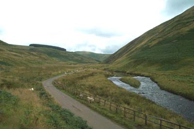
Windy Gyle from Coquet Valley
Northumberland Walk
Nat Park - Northumberland
County/Area - Northumberland County
Author - Lou Johnson
Length - 7.5 miles / 12.2 km Ascent - 1550 feet / 470 metres
Time - 5 hours 20 minutes Grade - moderate
Maps 

| Ordnance Survey Explorer OL16 | Sheet Map | 1:25k | BUY |
| Anquet OS Explorer OL16 | Digital Map | 1:25k | BUY |
| Ordnance Survey Landranger 80 | Sheet Map | 1:50k | BUY |
| Anquet OS Landranger 80 | Digital Map | 1:50k | BUY |
Walk Route Description
Click image to visit gallery of 6 images.
The upper reaches of the Coquet valley in the Northumberland National park provide a great feeling of remoteness. This walk takes to the high ground and starts roughly half a mile west of Windylaugh where ample parking is available on the grass verge near the confluence of Trows Burn with the River Coquet (grid ref. NT860114).
Head up the valley containing Trows Burn on the metalled lane that leads to the lonely farmsteads of Rowthorpe and Trows. Shortly after the latter farm a side track forks left off the valley track and immediately starts to climb quite steeply. After a short way the gradient eases and ahead you can see the large rounded shape of Windy Gyle although the summit will not come into view for some time yet.
Stay with the track with ever improving retrospective views back into Coquetdale. After just short of two miles the track meets a bridleway/footpath (grid ref. 860148). turn left (just north of west) for the final climb to summit of Windy Gyle, which is marked by a large cairn. There are superb views in all directions especially over Scotland.
If the visibility is good, Windy Gyle is a pleasant place to spend some time. All good things must end and you retrace your steps to the fence to pick up the Pennine Way as it heads south. The going is pleasantly easy as the path undulates along the ridge. Reaching a small col just before Mozie Law take the clear path that goes south over Black Braes. Stay with this ridge, choosing the best path for the conditions, over the flanks of Swineside Law. Known as "the Street" this ridge path leads you back to where you have parked.
Although this walk includes a two thousand foot summit the going, apart from a few boggy sections, is remarkably easy. The summit of Windy Gyle is reached without too much exertion and you have plenty of energy to enjoy the "deafening" silence so typical of this part of Britain. Whatever happens the landscape will captivate your imagination and you will certainly return to enjoy more of the Cheviots.
Other walks nearby
| Walk 2169 | Chew Green & Upper Coquet Valley | easy/mod | 5.8 miles |
| Walk 2251 | Yearning Saddle & Brownhart Law | moderate | 7.8 miles |
| Walk 3353 | The Roman Camp at Chew Green | easy/mod | 5.8 miles |
| Walk 3085 | The Dodd & Wether Cairn | moderate | 9.5 miles |
| Walk 2299 | The Cheviot | moderate | 9.0 miles |
| Walk 1766 | Cushat Law and Bloodybush Edge from Hartside | mod/hard | 12.5 miles |
| Walk 1764 | The Cheviot from Langleeford | mod/hard | 8.2 miles |
| Walk 1765 | Comb Fell & Hedgehope Hill from Langleeford | mod/hard | 8.9 miles |
| Walk 1776 | The Cheviot & Auchope Cairn from Langleeford | mod/hard | 10.0 miles |
| Walk 2152 | Hartshope Linn (waterfall) from Langleeford | easy | 4.4 miles |
Recommended Books & eBooks
Hadrian's Wall Path
 Hadrians Wall Path guidebook to walk the 84 mile National Trail. Described in both directions, the main description is west to east between Bowness-on-Solway and Wallsend, Newcastle, with extensions to Maryport and South Shields. With extensive historical information related to this World Heritage site and separate 1:25,000 OS map booklet included.
More information
Pennine Way Map Booklet
 Map of the 270 miles (435km) Pennine Way National Trail, between Edale in the Peak District and Kirk Yetholm in the Scottish Borders. This booklet is included with the Cicerone guidebook to the trail, and shows the full route on Ordnance Survey 1:25,000 maps. This popular long-distance route typically takes three weeks to complete.
More information
Messaging & Social Media
Message Walking Britain and follow the latest news.

Mountain Weather
Stay safe on the mountains with detailed weather forecasts - for iOS devices or for Android devices.