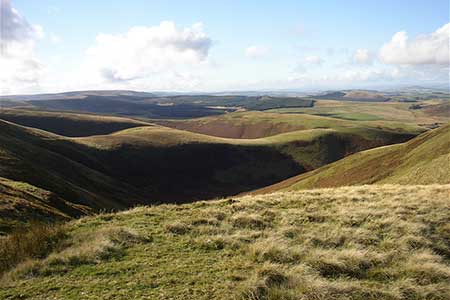
The Roman Camp at Chew Green
Northumberland Walk
Nat Park - Northumberland
County/Area - Northumberland County & Scottish Borders
Author - Lou Johnson
Length - 5.8 miles / 9.4 km Ascent - 800 feet / 242 metres
Time - 3 hours 40 minutes Grade - easy/mod
Maps 

| Ordnance Survey Explorer OL16 | Sheet Map | 1:25k | BUY |
| Anquet OS Explorer OL16 | Digital Map | 1:25k | BUY |
Walk Route Description
Click image to see photo description.
The Cheviot hills are amongst the wildest parts of England with only limited access by road to this part of the Northumberland National Park. This walk includes the Roman Camp at Chew Green and the Roman Signal Station a short distance to the north. The start is the small car park at Chew Green (grid ref. NT794085) at the head of Upper Coquetdale. The journey into the start provides a taste of the scenery to be enjoyed during the walk. From Rothbury take the B6341 through Thropton and after 2 miles take the minor road to Alwinton. From here follow the 'no through road' up Upper Coquetdale for just over 10 miles to Chew Green.
After parking walk west towards the Roman Camp at Chew Green to pick up the Pennine Way at grid ref. NT791084. Turn right onto the Pennine Way with the remains of the Roman Camp on your left. Continue north following the Pennine Way until your reach the border fence (grid ref. NT790095). A short diversion across the fence into Scotland will allow you explore the remains of the old Roman Signal Station which occupies a position with a wide ranging view across the border into Scotland.
Leave the Pennine Way at this point and take the path initially heading NE but soon swinging ENE to the Dodd. In approximately 600 metres from the border fence you join a bridleway heading towards Deel's Hill. The onward route follows a similar heading and descends across wild country to the road Buckham's Bridge (grid ref. NT824107). Turn right along the road back to Chew green and the parking area.
Other walks nearby
| Walk 2169 | Chew Green & Upper Coquet Valley | easy/mod | 5.8 miles |
| Walk 2251 | Yearning Saddle & Brownhart Law | moderate | 7.8 miles |
| Walk 1200 | Windy Gyle | moderate | 7.5 miles |
| Walk 1763 | Mozie Law & Windy Gyle | moderate | 8.2 miles |
| Walk 3085 | The Dodd & Wether Cairn | moderate | 9.5 miles |
| Walk 2299 | The Cheviot | moderate | 9.0 miles |
| Walk 3296 | Grubbit Law & Hownam Law from Morebattle | moderate | 7.0 miles |
| Walk 2163 | Darden Pike & Darden Lough | easy/mod | 4.2 miles |
| Walk 1766 | Cushat Law and Bloodybush Edge from Hartside | mod/hard | 12.5 miles |
| Walk 1201 | Black Hag from Kirk Yetholm | moderate | 8.5 miles |
Recommended Books & eBooks
Hadrian's Wall Path
 Hadrians Wall Path guidebook to walk the 84 mile National Trail. Described in both directions, the main description is west to east between Bowness-on-Solway and Wallsend, Newcastle, with extensions to Maryport and South Shields. With extensive historical information related to this World Heritage site and separate 1:25,000 OS map booklet included.
More information
Walking in Northumberland
 This guidebook contains detailed route descriptions for 36 day walks in Northumberland including the Cheviot Hills. The terrain varies from wild walks and craggy ascents to gentle riverside strolls. Each route ranges from 4 to 16 miles in length and there is the opportunity to link several walks together to create longer treks.
More information
Messaging & Social Media
Message Walking Britain and follow the latest news.

Mountain Weather
Stay safe on the mountains with detailed weather forecasts - for iOS devices or for Android devices.